Early British hydrographers were mostly young men who joined the navy in their teens, learning from the job as they moved up the ranks. Alexander Dalrymple was a young Scot sent out to join the East India Company, initially as a writer.[8] He was well read, having studied the voyages of the Spaniards, Magellan, Tasman, and other famous navigators of his times. In 1759, he was appointed to the Secret Service of the Company, working under Captain Baker on the schooner Cuddalore to explore the passages along the China coast. The Cuddalore brought Dalrymple to Macao, and it was on this occasion that he was given the task of charting the area to the east of the Pearl River Delta, the locale early British travellers had known to have good anchorage coves and deep water passages through a maze of islands to the open sea, away from Macao. At the young age of 21, Dalrymple managed to chart the islands and their adjacent waters with soundings in what he called “running surveys”. He did not actually claim them to be actual surveys, but were rather charts incorporating reports and other materials as compendiums of all available information. He obtained his latitude by observing the sun’s altitude at noon and longitude by lunar distance. The Cuddalore brought him to other regions such as the Philippines, Hainan and Borneo in the South China Sea where he was occupied delineating the coastlines through fixing each point by intersecting compass bearings of hilltops and headlands. The charts he gathered in these voyages formed the backbone of the materials in his published work, An Account of the Discoveries Made in the South Pacific Ocean Previous to 1764 printed in 1767.[9]
The running survey of the east bank of the Pearl River estuary became the first chart produced by Europeans of the Hong Kong region, even though Hong Kong Island, marked as Fang Chin Chow on the chart, was not clearly and completely demarcated.
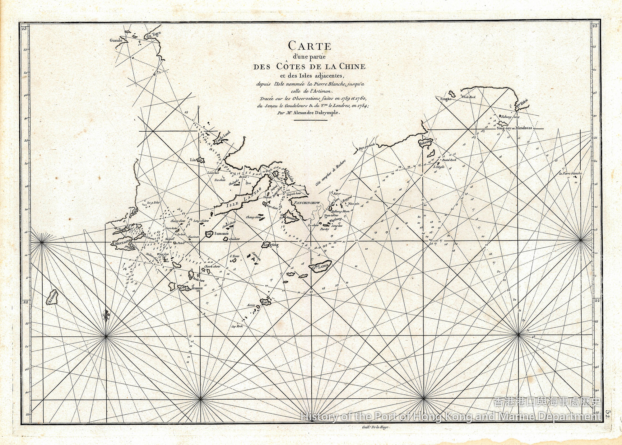
Plate 4: Alexander Dalrymple’s first chart of Hong Kong region.
Even though Hong Kong was not an English possession at the time, its potential had long been recognised by English traders in Guangzhou and Macao. Charting of these areas was considered important. Another hydrographer of the East India Company, James Horsburgh, was brought in to make a detailed survey of the area between Tsim Sha Tsui and the island of Hong Kong. Horsburgh also drew the attention of British traders to the potential of the waters south of Aberdeen and the present day Lamma Channel as good anchorage areas where fresh water supplies were available.[10]
Edward Belcher had his first taste of the ocean even earlier than Dalrymple — he went to sea at the age of thirteen in 1812. For a young cadet learning his trade as a deck officer and hydrographer amongst adults in the confined space of a sailing ship, Belcher was as intelligent as he was warlike and aggressive, traits he amply displayed when he was later called to survey the China coast during the First Opium War. After taking part in the actual hostilities on the steamer Nemesis, which damaged or sank a number of Chinese wooden junks, and laying siege to the Boca Tigris forts, he then captained HMS Sulphur when it glided into Hong Kong waters, and commenced the work of surveying the new colony.[11]
Skirmishes with Qing forces nevertheless continued, and each time Belcher was at the forefront of the lopsided and often sanguinary encounters against an opponent using mainly medieval weapons.
Belcher continued his survey during lulls in the war and could claim credit for the first chart of Hong Kong Island. It marked out places such as “Matheson’s Stores and Wharf” and “Happy Valley”. True to tradition, he dedicated the name of the ship he commanded, HMS Sulphur, to the channel, on the western approach of Hong Kong harbour. He also left behind his name for Belcher Bay and Belcher Street in Kennedy Town, western Hong Kong.[12]
Surveying techniques had greatly improved by the mid-nineteenth century. Belcher made extensive use of his knowledge of triangulation by deploying small rafts and beacons to mark and survey each triangular point, and his latitudes and longitudes were carried forward by plane trigonometry through the network of triangles he laid down. A sextant was proved to be a precision instrument to measure the altitude of the sun for latitude, and, the sextant and ship’s compass were used together to obtain a true bearing. Theodolite was already available, but was used more accurately ashore than onboard for measuring angles and altitude.[13] The Board of Longitude, established by an Act of the British Parliament in 1714, had 50 years later approved the chronometer created by clockmaker John Harrison. Regular supplies of this instrument were made available to British naval ships, together with tables to determine longitude by lunar distances.[14] It was these new scientific instruments and his excellent surveying techniques that make Belcher’s first chart of Hong Kong a splendid work to behold.
Notes:
- [8]G.S. Ritchie. The Admiralty Chart: British Naval Hydrography in the Nineteenth Century, (Edinburgh: The Pentland Press, 1995), p.21.
- [9]Ibid., p.22.
- [10]G.R. Sayer. Hong Kong 1841-1862 Birth, Adolescence and Coming of Age, (Hong Kong: Hong Kong University Reprint, 1980), pp.23-24.
- [11]G.S. Ritchie. The Admiralty Chart: British Naval Hydrography in the Nineteenth Century, (Edinburgh: The Pentland Press, 1995), p.250.
- [12]Ibid, pp.250-251.
- [13]Archibald Day: “The Admiralty Hydrographic Service 1795-1919”, (Her Majesty’s Stationery Office, 1967), pp 65.
- [14]Ibid., pp 243-244.

