Port facilities: navigational aids
For the sake of navigational safety, the Marine Department maintained a large number of navigational aids in different parts of Hong Kong waters throughout the 1950s and 1960s. For example, the Waglan Island Lighthouse had long been operating round the clock to guide vessels entering and exiting the harbour. More advanced equipment, such as a fog-signal facility, a ship/shore visual communication system, and a new power supply system were installed on the island in subsequent years.[42]
Other lighthouses, such as the Green Island Lighthouse and the Tathong Lighthouse, were also maintained and modernised by the Marine Department. From 1947 to 1967, the number of navigational aids increased from 22 to 96.[43]. Signal stations had also been established as aids to navigation. In 1950, on Green Island, from where there was better radio coverage of the territory, was established the third signal station, the first two being set up on Waglan Island and Blackhead’s Hill.[44] The signal stations operated round the clock, and they conveyed messages to vessels entering the harbour by using international code flags or signal lamps.
Furthermore, for the berthing of vessels, the government also provided moorings for vessels of up to 600 feet (183 metres). The number of government moorings increased from 44 in 1949 to 62 in 1965.[45] During typhoons, special typhoon moorings gave better protection to ships anchored in the harbour. Such moorings increased from 7 in 1949 to 25 in 1961, their effectiveness being proven during Typhoon Alice (1961) and Typhoon Wanda (1962), when not a single typhoon mooring was lost.[46] By 1960, most government moorings were located on the western side of Victoria Harbour, while a few were located in the waters off Kai Tak Airport for the anchorage of dangerous goods.[47]
Besides the above, there were private moorings for commercial vessels such as pleasure craft. These moorings were also regulated by the Marine Department. They developed rapidly between 1949 and 1965, by which time there were 724 private moorings.[48]
Port facilities: typhoon shelters, dockyards and godowns
Typhoon shelters were also provided. In the early 1960s when the demand was great, there were two typhoon shelters in Hong Kong, namely the Yau Ma Tei and Causeway Bay Typhoon Shelters[49]. These two shelters mainly catered for smaller vessels. Ocean-going vessels up to 32 feet (10 metres) draught could anchor in sheltered areas off Kowloon Peninsula or Hong Kong Island. There were 12 deep berths on both sides of the harbour.[50]
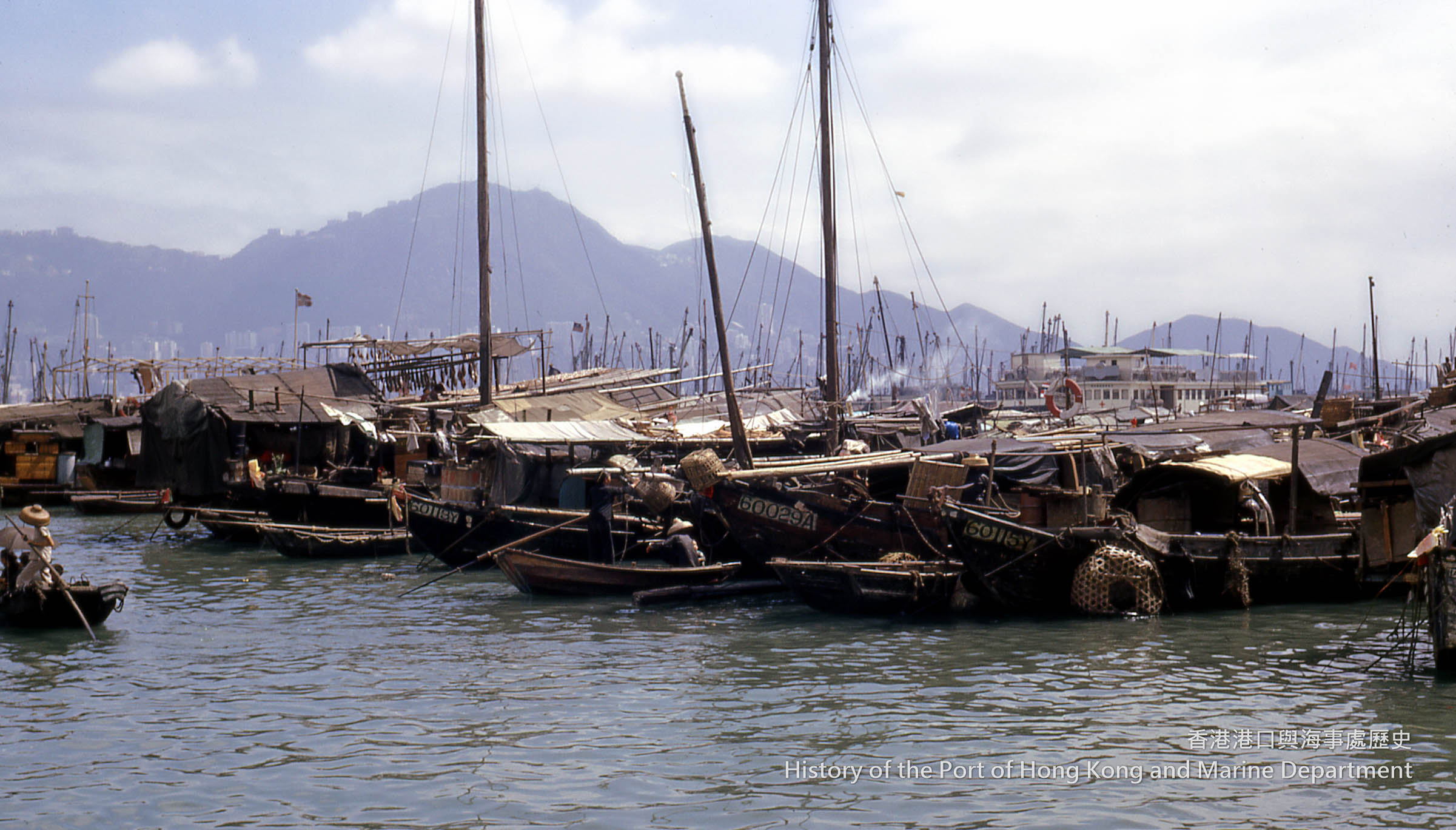
Plate 10: Junks in the Yau Ma Tei Typhoon Shelter, 1965
Being a famous entrepot in the Far East, Hong Kong had well-equipped dockyards and slipways. In the post-war period, the Government Slipway in Yau Ma Tei was furnished with modern and diversified facilities for the maintenance of government vessels, such as cradles, workshops, stores, and fuel tanks. Private companies like the Hong Kong and Whampoa Dock Co. Ltd. and Taikoo Dockyard operated private dockyards which excelled in ship-repairing. Statistics show that in 1958-1959 at least 1,600 vessels were repaired in Hong Kong. The Hong Kong and Whampoa Dock Co. Ltd. possessed five graving docks and different kinds of workshops for ship-repairing, while Taikoo Dockyard had a graving dock of 787 feet (240 metres) in length for ship-repairing. They were fully equipped with various types of cranes, such as hammer head cranes, monotower cranes, and travelling cranes. The two companies also built ships. Whampoa owned seven major berths, the largest being able to accommodate a ship up to 700 feet long. Taikoo had four berths for constructing vessels.[51]
Many godown companies, such as the Hongkong & Kowloon Wharf & Godown Co. Ltd. and North Point Wharves Ltd., were set up beside the berths to facilitate cargo handling.[52] Some huge godowns could store up to 100,000 tonnes of cargo. These godowns were supported by modern facilities, such as electric cranes, light railway systems, side loaders, fork-lifts and mobile conveyors.[53] Such modern facilities made storing timber, logs, dangerous goods and other special goods much more convenient. The Hong Kong Harbour Plan, 1966 indicates the locations of the godowns and wharves, which were mainly found in Tsim Sha Tsui and North Point.[54]
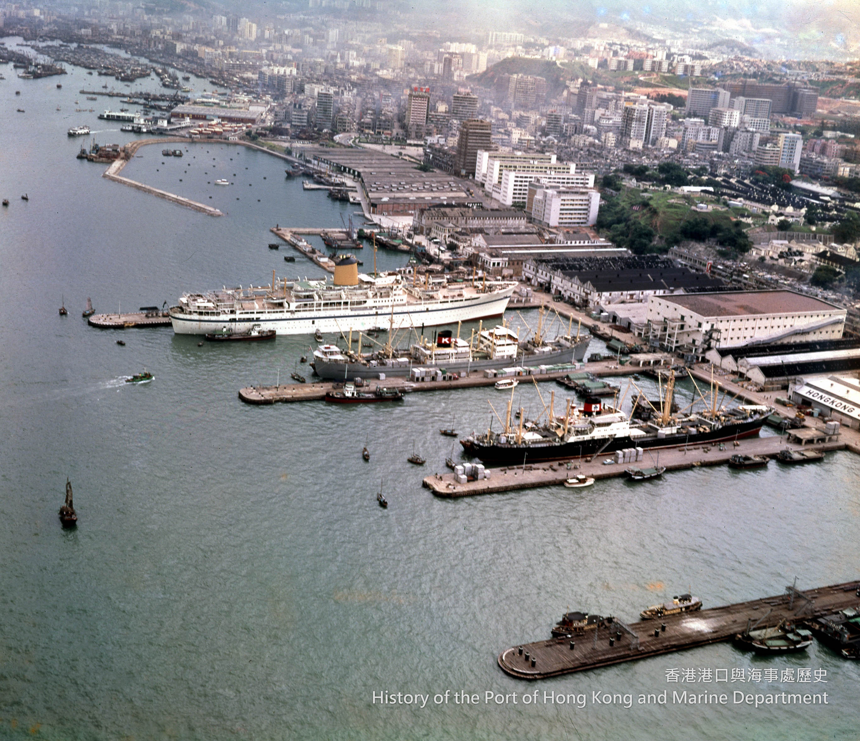
Plate 11: Aerial view of the Hongkong & Kowloon Wharf & Godown Co. Ltd., 1963
Port facilities: terminals and piers
With the shipping industry developing rapidly, there were demands for a large cruise terminal. Thus, the Hong Kong & Kowloon Wharf & Godown Co. Ltd. took the initiative to plan and build a cruise terminal along the Kowloon waterfront next to the Star Ferry Pier in 1962. The proposal was endorsed by the government. Upon its completion in 1966, the Ocean Terminal provided a main deck area of 312,500 square feet (29,032 square metres). Two large liners or four medium-sized vessels could berth simultaneously alongside the two sides of the Ocean Terminal.[55] Besides, a large shopping mall and a big car park were constructed there, transforming the area into a commercial and tourist centre.[56]
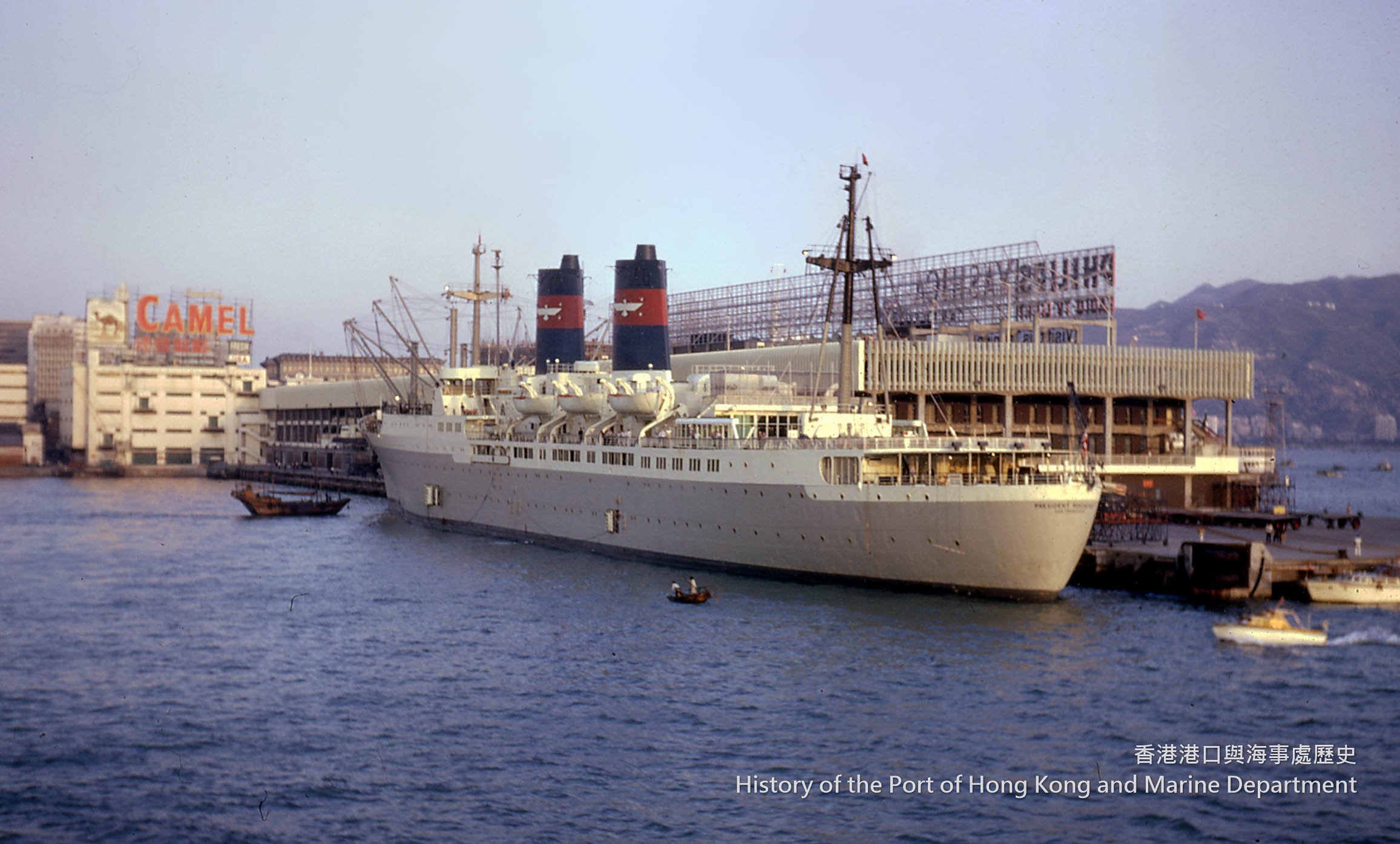
Plate 12: The Ocean Terminal, 1966
In the years 1948-49, the ferry network carried more than 64,500,000 passengers and 426,000 vehicles.[57] Confronted with rising numbers of commuters, the government improved the piers to meet growing demands. For example, the new Queen’s Pier started operation in June 1954; the construction of the new Blake Pier was confirmed in the same year; and the old Blake Pier was finally demolished in the 1960s.[58] To cater for the transportation needs of the 3,000 residents and factory workers on the outlying island of Peng Chau (坪洲), the government approved the HYF’s proposal to build the Peng Chau Pier, which opened in June 1954.[59]
Plate 13: Constructing the Blake Pier, 1964
Port facilities: reclamation
Reclamation was another way to develop Hong Kong’s harbour. From the 1950s to the 1960s, the government implemented various reclamation schemes to increase the size of the harbourfront. Starting from 1951, three major reclamation projects were undertaken to improve the usability of the harbourfront. They took place at North Point, Causeway Bay, and Central respectively. The reclaimed land in Central under the Central Reclamation Scheme was also used for public amenities.[60] The reclamation projects paved the way for commercial activities and property development, further strengthening Hong Kong’s economy. Making good use of the reclamation projects, the Marine Department grasped the opportunity to upgrade waterfront port facilities such as piers and departmental offices through reconstruction.
Port facilities: fairways
In the 1960s, there were only three fairways in the harbour, namely the Northern Fairway, the Central Fairway, and the Southern Fairway.[61] In response to rapid industrialisation and increasing trading volumes, the need for traffic regulation was greatly increased. Consequently, schemes were adopted to improve the safety of the port. The Western Harbour Scheme of 1963 aimed at providing a wide and clear fairway, mainly in the western part of the harbour, for ocean shipping, as well as increasing the work efficiency of ocean mooring buoys. Thus, the harbour limit was extended, enabling the placement of an increasing number of buoys, and the fairways were realigned and marked. The anchorages were also relocated. For example, the Quarantine and Immigration Anchorage and the Western Dangerous Goods Anchorage were moved farther westward.[62]
A year later, the Hung Hom Fairway was established to link up with the Central Fairway. It led into the Central Harbour, complementing the Western Harbour Scheme. As part of the Central Harbour Scheme, the Hung Hom Fairway connected the eastern and western parts of the harbour and facilitated movement of ships entering the port.[63] Additionally, improvements to the western part of the port following the launch of the Western Harbour Scheme offered seafarers a safer sailing environment. The harbour mooring facilities and components were rearranged and enhanced under the scheme in the same year.[64]
Notes:
- [42]Marine Department Annual Departmental Report, 1950-51, p. 2; 1951-52, p. 3; 1964-65, p. 34.
- [43]Marine Department Annual Departmental Report, 1966-67, p. 88.
- [44]Marine Department Annual Departmental Report, 1949-50, pp. 3, 37.
- [45]Ibid., p. 1; 1964-65, p. 28.
- [46]Ibid., p. 1; 1961-62, p. 8; 1962-63, p. 29.
- [47]Map: Hong Kong Harbour Plan, 1960.
- [48]Marine Department Annual Departmental Report, 1964-65, p. 31.
- [49]D A Taylor, The Port of Hong Kong, (Hong Kong: Book Marketing Limited, 1991), pp. 42-45.
- [50]陳大同、李汝祥編:《香港海空指南》(香港:中國新聞社,1951),頁1。
- [51]Hong Kong Shipping, Engineering and Aviation Guide 1958-59, (Hong Kong: C M Wolosh Ltd, 1959), pp. 15-17, 33-37.
- [52]Map: Hong Kong Harbour Plan, 1960.
- [53]Hong Kong Shipping, Engineering and Aviation Guide, Hong Kong: C M Wolosh Ltd, 1958-59, p. 89; Chiu, T N, The Port of Hong Kong: A Survey of its Development, Hong Kong: Hong Kong University Press, 1973, p. 110.
- [54]Marine Department Annual Departmental Report, 1965-66, p. 132.
- [55]Marine Department Annual Departmental Report, 1964-65, p. 3.
- [56]Hong Kong Shipping, Engineering and Aviation Guide, 1962-63 (Hong Kong: C M Wolosh Ltd, 1963) , p. 107.
- [57]Marine Department Annual Departmental Report, 1948-49, p. 8.
- [58]Marine Department Annual Departmental Report, 1954-55, p. 8.
- [59]HKRS 156-1-3388, Ferry Pier at Ping Chau Island, NT – 1. Application form the Hong Kong & Yaumati Ferry Co. Ltd., 12.02.1951-25.11.1968, Hong Kong Public Records Office, 1, 8, 31.
- [60]T. N. Chiu, The Port of Hong Kong, p. 104.
- [61]Map: Hong Kong Harbour Plan, 1960.
- [62]Map: Hong Kong Harbour Plan, 1964.
- [63]Marine Department Annual Departmental Report, 1964-65, p. 28.
- [64]Marine Department Annual Departmental Report, 1963-64, pp. 2, 7.

