As more Europeans arrived off South China to trade, it was apparent by the mid-Qing that the threat from overseas maritime powers had become overwhelming, forcing the Qing authorities to reinforce the coastal defence fortifications first built in the Ming Dynasty.
In 1394, the Ming Emperor Hongwu (洪武) decreed the establishment of an anti-piracy squad along the Guangdong coast to be led by a deputy commander.[39] As a consequence, Hong Kong came under the control of Dongguan (東莞).[40] Two walled defence barracks were built, one at Nantou (南頭) and the other at Dapeng (大鵬), each manned by hundreds of soldiers, to be responsible for defence both on land and at sea. Since the implementation of the pan-Guangdong defence plan in the 29th year of Jiajing (1550), the Hong Kong region belonged to the “central sector”, and was considered strategically important as the frontier for Guangzhou, the provincial capital.[41]
The Hong Kong region was incorporated into this defence network when a military base, the Kwun Fu Magistracy was erected in East Kowloon, garrisoned by 50 archers.[42] Other defence infrastructure included signalling stations (烽堠) built at strategic locations along the coast.[43]
Apart from fortifications on land, naval forces were deployed and integrated into the defence system. In the case of Hong Kong, the sea area was patrolled by armed junks deployed from Dapeng. Since the arrival of the Portuguese in Macao, the Ming authorities had strengthened the naval force at Xiangshan (香山) to keep a watchful eye on foreigners’ activities. Some of the former’s naval boats would sail across the Pearl River estuary to “join forces” with their compatriots at Tai O, Lantau Island.[44]
Towards the end of Ming, Nantou and the Hong Kong region were upgraded from being part of Dongguan to become an independent county named Xinan (新安). Nantou, with its walled barracks, was chosen as the seat of the new county. This administrative organisation remained unchanged throughout the Qing. Naval patrols in Hong Kong waters were deployed from Dapeng, while Tuen Mun area was protected by junks despatched from Nantou.[45]
In 1810, after the pirates based in Tung Chung were pacified, the Qing authorities felt that the sea distance from western Lantau Island to Dapeng was too far for naval patrols to be effective. A decision was made to build another barracks in Tung Chung, naming it the Dapeng Right Camp (大鵬右營). This structure, known also as Tung Chung Fort, is still extant.[46]
It is important to note that even though Macao had drawn much of the attention from the authorities on defence matters, the Qing court did not lose sight of the importance of the east bank of the delta area. In 1836, when the problems of British traders and the opium trade arose, the authorities strengthened the defence line on the east delta by establishing five important checkpoints, namely Yantian Checkpoint (鹽田汛), Tuoning Battery (沱濘炮台), Kowloon Battery (九龍炮台), Hung Heung Lo Maritime Checkpoint (紅香爐水汛), and Tai Yu Shan Battery (大嶼山炮台), which were all under the control of Dapeng Barracks.[47]
Hong Kong had been called Hung Heung Lo ever since the name appeared in Chen Lunjiong’s The Complete Map of the Coastline (陳倫炯《沿海全圖》) of 1730. The name was commonly used in most maps and documents until 1841.
Since the Jiaqing reign (1796-1820), there had reportedly been a checkpoint in Hong Kong,[48] but it was not until the Daoguang (道光) reign (1821-1850) that the term “maritime checkpoint” (水汛) was specially mentioned to distinguish it from the usual “land checkpoint”(亭步汛).
At one time, the Hong Kong checkpoint was called a “camp checkpoint”(營汛), and was considered more important and commanded more resources. As such, for patrolling the important waterways from Fat Tong Mun to Kap Shui Mun, boats were not sent from Dapeng. According to the Guangdong Gazetteer, apart from being staffed by military officers including one qianzong (千總) and one waiwei (外委), the Hung Heung Lo Maritime Checkpoint was provided with rice boats, which could be used for patrol duties.[49] Hence, it is noteworthy that Hong Kong was one of the biggest checkpoints erected on an outlying island on the east bank of the estuary.
In the map on Ruan Yuan’s Guangdong Gazetteer, the Hung Heung Lo Maritime Checkpoint was drawn with a stockade, a public building within the perimeter, a signalling station and a high sentry tower. In comparison, the setup of Yantian Checkpoint in the northeast had no public building inside the stockade. Further north, the checkpoint at Tiejiang Tang (鐵江塘) did not have any signalling facility. The Hung Heung Lo Maritime Checkpoint therefore looked very much more sophisticated as a defence, administrative and maritime checkpoint.
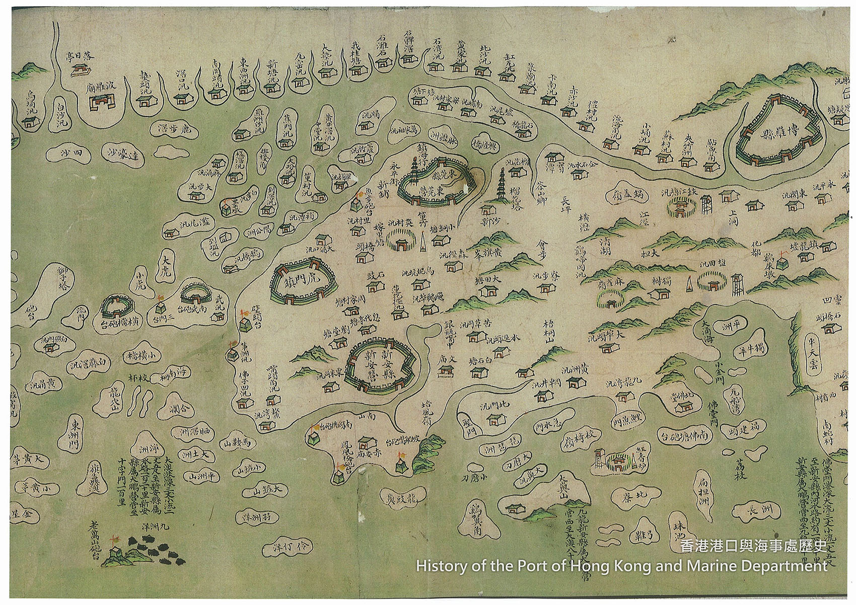
Plate 1: Guangdong Coast Administrative Map showing Hung Heung Lo and other checkpoints along the coast.
A maritime checkpoint served several purposes, including regulating all seaborne traffic. For this purpose, Hung Heung Lo was more significant as it was astride the main coastal traffic waterway between Guangzhou and all northern provinces. Officers from the stockade would interrogate passing vessels on the purposes of their voyages, the nature of their cargoes, their tax papers, and their passenger and crew lists. An imperial decree was promulgated in the early Qing encouraging officers to search for contraband cargoes. Those who successfully intercepted illicit goods would be given substantial rewards equal to half the value of the cargoes confiscated.[50]
In addition, the checkpoint could also act as the control point of customs, issuing permits for vessels owned and operated by local residents.[51] It was also a patrol-boat station, and its craft patrolled the surrounding waters at regular intervals. Finally, the maritime checkpoint also served as a rescue centre in the event of marine accidents.[52]
Despite its importance, the Hung Heung Lo Maritime Checkpoint was under the direct command of the Naval Superintendent (水師提督) at Dapeng.
Active measures were taken to strengthen the coastal defence system in Guangdong during the early Qing. An arsenal was built at Dapeng in the Yongzheng (雍正) period, and an ammunition depot was added during Qianlong times.[53] Towards the late Qing, however, government finances were stretched. Funds available for the building and maintenance of naval battleships were therefore limited.[54]
When the pirate Zhang Bao surrendered to the authorities in 1810, most of his fleet, about 200 ships strong, was quickly snatched up and shared amongst various coastal navy stations to supplement the inadequacy of their forces.[55] By the time of Daoguang, the Dapeng Barracks only had a fleet of three “big rice boats” (大米船), two “medium-sized rice boats” (中米船) and two “laozeng boats” (撈繒船), while its Tung Chung subsidiary (named Dapeng Right Camp 大鵬右營) possessed two “big rice boats”, two “medium-sized rice boats” and one “laozeng boat”. In sum, there were only nine poorly equipped sailing boats plus three small coastal junks to patrol and maintain the peace of the coastal areas, including all the outlying islands from the east bank of the Pearl River delta to the east of Dapeng Bay.[56] This was also the time when foreign traders were making great profits from smuggling opium into China in specially constructed “fast crab” (快蟹) rowing boats, which could outrun all government vessels. Because of these illicit seaborne activities, the vessels at Tung Chung were used to keep an eye mainly on the coast north of Lantau from Kap Shui Mun to the Tuen Mun area.[57]
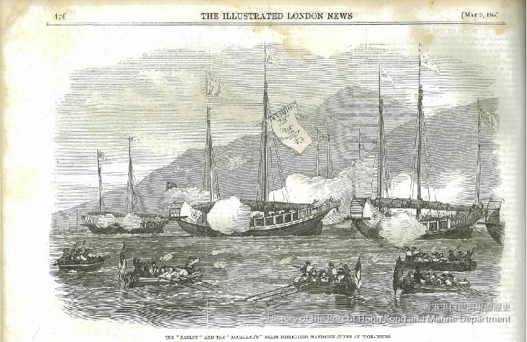
Plate 2: A western artist’s depiction of rice boats in battle at Tung Chung.
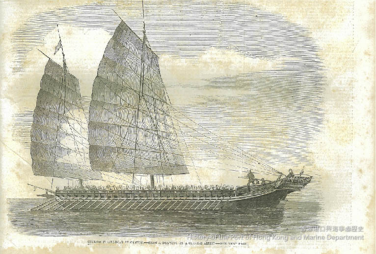
Plate 3: A picture of the smuggling “fast crab” rowing boats.
One final point to note is the exact location of the Hung Heung Lo Maritime Checkpoint on Hong Kong Island. Guangdong Tushuo (《廣東圖說》) indicated that the checkpoint was on the east of the island.[58] In the Hong Kong Government Gazette published on 15 May 1841, some important population statistics were released. The biggest town on the island was Chuck Chu[59] (today’s Stanley, 赤柱) with 2,000 residents, followed by Shau Kei Wan (筲箕灣) with 1,200. Among smaller settlements, there was a village named Hung Heung Lo (紅香爐) with a population of 50. Local scholars have discovered a stone carving dated to 1868 that was erected to commemorate the renovation of the Tin Hau Temple on Tin Hau Temple Road in Causeway Bay.[60] According to the tablet, the temple was previously called Hung Heung Lo Tin Hau Temple,[61] indicating the temple must have been near to or possibly part of the maritime checkpoint of Hung Heung Lo. On visiting the site, one may note that, unlike most Tin Hau temples that were usually built on seafronts, the temple is perched on the spur of a hillside, commanding a good vantage point for observing vessels in the harbour. Hung in the main hall, and highlighting the long history of this “Hung Heung Lo Tin Hau Temple”, is a bronze bell dating to 1727 (the 5th year of Yongzheng), one of the oldest relics in Hong Kong.

Plate 4: Guangdong Tushuo showing the Hung Heung Lo Checkpoint.
Notes:
- [39]顧炎武:《天下郡國利病書》,卷101。
- [40]王崇熙:《新安縣志》,頁26。
- [41]盧坤、鄧廷楨:《廣東海防彙覽》,卷二,輿地一,險要一,頁31。
- [42]盧坤、鄧廷楨:《廣東海防彙覽》,卷六,職司一(石家莊:河北人民出版社,2009),頁196;胡宗憲:《籌海圖編》,卷三,頁5;茅元儀:《武備志》,卷213,頁6。
- [43]靳文謨:《新安縣志》,卷八,兵刑志、墪堡之南頭寨條。
- [44]嚴如熠:《洋防輯要》,卷二:「…香山協副將與吳川營都司會哨於廣海大澳,龍門協副將與海口營參將會哨于白沙,其總巡以及各營分巡定期會哨」。
- [45]王崇熙:《新安縣志》,卷十,經政四、兵制。
- [46]盧坤、鄧廷楨:《廣東海防彙覽》,卷32,方略21,砲臺二。
- [47]梁廷枏:《粵海關志》,卷二十,兵衛;王崇熙:《新安縣志》,卷十,經政四、兵制。
- [48]蕭國健:《清代香港之海防與古壘》(香港:顯朝書室,1982),頁2;王崇熙:《新安縣志》,卷十一,經政略、大鵬所防守營條。
- [49]阮元:《廣東通志》,卷175,經政略,兵制三、大鵬營條。
- [50]梁廷枏:《粵海關志》,卷十七,禁令一,〈苛勒之禁〉。
- [51]阮元:《廣東通志》,卷124,海防二:「所有器械,俱須鑿鏨船户姓名,號數,開載照票,税關先驗州縣印照明白方許給牌,如有言給照州縣給照之例處分,汛口盤查掛號,文武官弁疎縱及勒索者,發覺俱降二級。」,可見汛口亦擔當海關之掛號任務;盧坤、鄧廷楨:《廣東海防彙覽》,卷33,方略二十二,保甲:「乾隆21年,…沿海州縣指各港小漁船隻逐一徹底清查,換給印照。…書交營汎收執」。
- [52]Wang Gungwu and Ng Chin-keong ed., Huang Guosheng, ‘The Chinese Maritime Customs in Transition, 1750-1830’, in Maritime China in Transition 1750-1850 (Wiesbaden: Harrassowitz Verlag, 2004), pp. 169-189. Xinan was listed as one of the customs station under the Guangdong Customs. While coastal trade from Guangdong to Fujian and other northern provinces had thrived since 1750, some branch stations were set up focusing on the coastal trade. No such branch stations’ names were put on record, it could be assumed that Hung Heung Lo, sitting on the important coastal trade route to the north, could have played a role in this customs network.
- [53]阮元:《廣東通志》,卷130,建置略六。
- [54]盧坤、鄧廷楨:《廣東海防彙覽》,卷11,財用二,積貯:「玆據奏稱該省添做米艇,配製炮械及添撥弁兵,修理舊船,給發口糧等項,需費繁多,所有留粵支用之鹽關盈餘及武職空缺養廉、田房税羨各項银両,支用不敷」。
- [55]梁廷枏:《粵海關志》,卷二十,兵衛十四。
- [56]梁廷枏:《粵海關志》,卷二十,兵衛四十二。
- [57]Ibid.
- [58]《廣東圖說》,卷十三,新安七:「香港島舊有居民數十户,東有紅番爐汛,東南有赤柱汛」。
- [59]Chuck Chu was renamed Stanley on 13 March 1845. See The Friend of China and Hong Kong Gazette, 15 March 1845.
- [60]科大衛等編:《香港碑銘彙編》,第一冊(香港:香港市政局,1986),頁129。
- [61]James Hayes, ‘Hong Kong Island before 1841’, Journal of the Royal Asiatic Society Hong Kong Branch (JHKBRAS), 24 (1984), p. 127.

