Pilotage is compulsory in Hong Kong Waters.
In general, ship, other than an exempted ship, while navigating in Hong Kong Waters shall be under the pilotage of a licensed pilot(s) if it is 3,000 gross tons (GT) or over, 1,000 GT or more carrying certain classes of dangerous goods or a gas carrier. Schedule 1 to the Pilotage Ordinance Cap.84, assessable at the link below, gives details of ships subject to compulsory pilotage.
<https: www.elegislation.gov.hk="" hk="" cap84?pmc="1&xpid=ID_1438403567418_002&m=1&pm=0>
Pilotage service in Hong Kong is operated by commercial enterprises and available 24 hours a day. Information on the service provider is available at the following link:
<https://www.mardep.gov.hk/en/public-services/shipping-directory/index.html>
Ships carrying a pilot should fly an international code flag "H"

Government Departments of both Hong Kong and Shenzhen has signed the framework agreement on co-operation in Mirs Bay pilotage. Vessels that are required to be under compulsory pilotage as stipulated in the laws of both Hong Kong and Shenzhen will be piloted by a single Hong Kong or Shenzhen qualified pilot throughout the entire voyage to or from the Shenzhen East Port Area through Mirs Bay.
Hong Kong has nine pilot boarding stations :
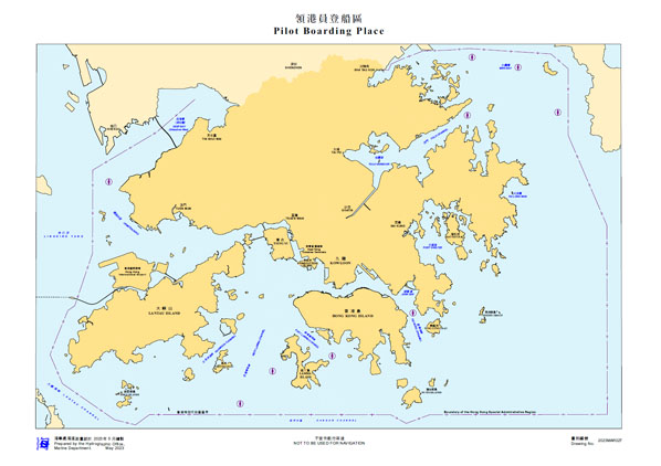
| 1 | Ha Mei Wan, west of Lamma Island | An area of 0.5 nautical mile radius centred by position latitude 22°11.908΄ north, longitude 114°05.447΄ east. |
| 2 | Turning buoy in the Tathong Channel | An area of 0.4 nautical mile radius centred by position latitude 22°15.908΄ north, longitude 114°15.814΄ east. |
| 3 | Lam Kok Tsui (Black Point) in Urmston Road | An area of 1.0 nautical mile radius centred by position latitude 22°24.925΄ north, longitude 113°53.347΄ east. |
| 4 | Entrance to Tolo Channel | An area of 0.5 nautical mile radius centred by position latitude 22°29.508΄ north, longitude 114°19.848΄ east. |
| 5 | Ngan Chau in East Lamma Channel | An area of 0.5 nautical mile radius centred by position latitude 22°12.958΄ north, longitude 114°09.847΄ east. |
| 6 | Ping Chau in Mirs Bay | An area of 0.5 nautical mile radius centred by position latitude 22°32.800΄ north, longitude 114°23.600΄ east. |
| 7 | Crooked Island in Mirs Bay | An area of 0.5 nautical mile radius centred by position latitude 22°33.500΄ north, longitude 114°20.200΄ east. |
| 8 | Shek Ngau Chau in Mirs Bay | An area of 0.5 nautical mile radius centred by position latitude 22°29.700΄ north, longitude 114°26.540΄ east. |
| 9 | South of Cheung Chau Island | An area of 0.7 nautical mile radius centred by position latitude 22°09.663΄ north, longitude 114°03.055΄ east. |
The Director of Marine is the Pilotage Authority and he is advised on all pertinent matters by the Pilotage Advisory Committee.